


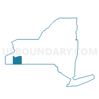
Voting District 130001, Cattaraugus County, New York
About
Outline

Summary
| Unique Area Identifier | 625667 |
| Name | Voting District 130001 |
| County | Cattaraugus County |
| State | New York |
| Area (square miles) | 16.19 |
| Land Area (square miles) | 16.15 |
| Water Area (square miles) | 0.04 |
| % of Land Area | 99.76 |
| % of Water Area | 0.24 |
| Latitude of the Internal Point | 42.16811680 |
| Longtitude of the Internal Point | -78.42690140 |
Maps


Graphs
Select a template below for downloading or customizing gragh for Voting District 130001, Cattaraugus County, New York


Neighbors
Neighoring Voting District (by Name) Neighboring Voting District on the Map
- Voting District 010003, Cattaraugus County, NY
- Voting District 130002, Cattaraugus County, NY
- Voting District 140001, Cattaraugus County, NY
- Voting District 150001, Cattaraugus County, NY
- Voting District 230002, Cattaraugus County, NY
Top 10 Neighboring County Subdivision (by Population) Neighboring County Subdivision on the Map
- Allegany town, Cattaraugus County, NY (8,004)
- Hinsdale town, Cattaraugus County, NY (2,168)
- Olean town, Cattaraugus County, NY (1,963)
- Ischua town, Cattaraugus County, NY (859)
- Humphrey town, Cattaraugus County, NY (687)